|
Along the years, the Power Systems Unit developed
planning tools which have helped to structure the best ways
to integrate the renewable energies and understand the
phenomena of interaction between the energy needs and the
environmental and social concerns. These tools are being
applied to countries such as Cape Verde, Brazil, Spain and
recently, some of the countries in the Balkans. Most of
these works have generated many publications for conferences
and, in the last two years alone, five publications in
prestigious scientific magazines in the areas of power and
energy.
 The
history The
history
Since 1993, the Power Systems Unit (USE) has been using the
potential of Geographical Information Systems (GIS) to take
care of problems concerning the planning of electrical power
systems. These are an increasing area of research for
environmental criteria combined with criteria of use of
territory.
This aspect has motivated the use of GIS as a support
tool, not so much as an information system but more as a
calculation tool that extends complex calculation procedures
for a geographical dimension in which these procedures are
repeated thousands of times with different geographical
variables. The renewable energies are one of the areas where
these methodologies have been applied due to the strong
relation between these endogenous energies and the
geographical variables.
 The
project that started it The
project that started it
The first project of experience in this area of research was
SOLARGIS (Integration of Renewable Energies for
Decentralized Electricity Production). Started in 1993, the
objective of this European project was precisely to explore
methodologies of regional planning applied in several
regions of Europe and Africa.
SOLARGIS germinated a set of methodologies of mapping of
resources and potentials whether for small isolated
photovoltaic systems or for bigger electrical systems
connected to networks and to the electrical network.
 On
its way to Amazonia On
its way to Amazonia
When this project was finished, interests in these
methodologies arose, in order to try to solve the same kind
of problems in the Amazonia region. This would be one of the
most complete works carried out until now, covering a wide
range of methodologies for the several energetic
technologies with potential in the region.
These methodologies included algorithms of estimation of
optimal costs of transportation (of equipment, of
maintenance crews, etc.). These algorithms were meant for
wind, solar and biomass resources, for the mapping of the
cost of electricity production of each energy technology and
methodologies to compare the efficiency of a diversity of
power generation technologies giving the several regions
grounds for a political decision.
 The
connection to the economy The
connection to the economy
The GIS were applied to problems of planning of powerl
distribution networks while the projects were running and as
a part of Masters or PhD theses. Tools for economical
optimization of the location of sub-stations were developed
as well as an economical optimization of the layout of the
electrical network.
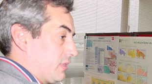
Cláudio Monteiro, researcher in the area of Renewable
Energies and Planning of Electrical Distribution Systems of
the USE, states these works will allow the integration of
models of computational intelligence inside a diversified
environment of geographical variables. The engineer reveals:
“In this area we develop interesting concepts of
geo-computational intelligence such as the use of diffuse
inference to learn and simulate complex patterns of
geographical behaviour such as the city’s geographical
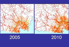
growth and the matching consumptions of electricity”.
 Looking
for a consensus of interests Looking
for a consensus of interests
In the last years, through collaboration with the University
of La Rioja, in Spain, new methodologies have been
developed. Their objective is to help find a consensus in
energy problems with geographical conflict. The solutions
involve the creation of maps of consensus between
environmental interests and economic interests for the
installment of wind parks.
Methodologies to help in the negotiation of right-of-way
paths for high voltage overhead lines were developed, aiming
to obtain technical solutions from consensus leading to a
good economical and environmentally acceptable geographical
layout.
 The
added values of the regional planning The
added values of the regional planning
These works in the area of negotiation aid have caught the
researchers’ attention given that they aid the decision
agents involved and help understand and visualize the
multiple criteria at stake in a regional planning, in a
broader geographical scope.
These methodologies enable the visualization of regional
plans that were limited by the focus on minor local
interests, facing more important goals fixed at a regional
or national level.
 The
environmental impact The
environmental impact
The tools in question make use of methodologies that join
the technical and economical evaluation, geo-computational
intelligence, modeling of social behaviour and particular
concepts related to the environmental impact of electrical
infra-structures.
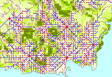
In the area of environmental impact, a GIS methodology to
map the visual impact of wind parks was developed. Besides
using GIS algorithms for the calculation of visibility, they
performed an important work based on photo montages and
surveys, of parameterization of the perception of the impact
created by the wind power generators in the people who see
them.
 The
most recent projects of USE The
most recent projects of USE
Currently, the Power Systems Unit is involved in two
projects related to GIS. One of them is the European project
RISE (Emergency Situations Information Network) whose
objective is to promote renewable energies in countries
affected by war, such as Bosnia, Croatia, Serbia, Montenegro
and Macedonia. The other project is REWEB (Internet provider
for geographical evaluation of small projects of Renewable
Energies).
REWEB is an FCT – Foundation for Science and Technologym
Portugal project, whose objective is to implement
methodologies of evaluation of small systems of renewable
energies in a platform of web service. The concept is to
allocate general information to a centralized server of
private information given by the client himself. This new
approach will allow the client to massively use these
software tools which are generally hard to access, and it
will also offer the server a better centralized management
of maps of resources, energy technology databases and
economic and environmental models for evaluation of the
alternatives.
 The
new unexplored areas The
new unexplored areas
Cláudio Monteiro believes there are still unexplored areas
of research. He states: “In the areas of the renewable
energies, we still have to step into the sea, addressing
power generation technologies and offshore energy transport,
such as wind, wave energy, coastal currents, among others”.
In the area of power networks, the Professor considers there
is still a lot to do in the modeling of the interaction with
the real world that is related to these systems, such as the
modeling of computational intelligence to infer the
influence of environment factors on power system
reliability, such as meteorology, plant life, human activity
and fires.
 The
future is multidisciplinar The
future is multidisciplinar
The researcher considers that the concepts of energy,
environment, territory and social behaviour are increasingly
overlapping. He ensures “this tendency propels a growing
interest in methodologies with a capacity for geographical
planning that crosses the thematic areas of energies with
other areas related to planning”.
Always optimistic, Cláudio Monteiro believes this
tendency will motivate new projects applied in Portugal and
elsewhere in the world
<< Previous
| Next >>
|